Sunday, December 30, 2012

Sunday Sunlight


The rising sun illuminates Monarch Ridge and the setting moon, as seen from the deck of the Mountain Deck Home in Garfield on March 17, 2009.

Thursday, December 27, 2012

Three-4-Thursday


San Juan River

Here are three pointers, in honor of the Spurs' record barrage of three-pointers against the Mavericks this past Sunday.


Instructor Zoltan at the petroglyphs near mile 3.6 on the San Juan River.


Professor Mike instructs student Robert at the Butler Wash Petroglyph Panel at Mile 4.7.


"Go west young man."  Actually, Mike is pointing to the south-east after we climbed up a side canyon to the east of Chinle Wash on the second day of our San Juan River adventure.  He had located another small branch of the drainage, one which would enable me to climb to the top of the high bluff and its alcoves.

Wednesday, December 26, 2012

Wednesday Wildlife


A mother yellow-bellied marmot (Marmota flaviventris) casts a wary eye on David Eisenhauer and me as we hike the Continental Divide Trail from Marshall Pass to Monarch Pass on July 22, 2007.

Tuesday, December 25, 2012

Two-4-Tuesday


Rio Chama 2012 - Aragon Rapid


 Amy and Jon challenge the rapid with fully-loaded canoes on August 18.


Sunday, December 23, 2012

Sunday Sunlight


These two photos were taken from the Amen Mountain Deck Home in Garfield, Colorado, looking east down the valley towards Salida.  The first was taken on August 23, 2009, as the sun set behind us.  The other is of the sunrise four days later.


Thursday, December 20, 2012

Three-4-Thursday


Rio Chama 2012 - Aragon Rapid


Ten of us launched our boats onto the Rio Chama at Cooper's El Vado Ranch on August 16.  After spending two nights at Aragon Camp, we reloaded our boats and headed down the river.  But we first had to negotiate Aragon Rapid.  The rapid had been changed significantly since our trip the prior year, and been made much more challenging, by a large boulder which had broken free from the cliff face above and fallen into the river.  A few of us decided to portage the rapid, but most of us ran the rapid in fully loaded boats.


Mike and the Dagger Dimension were up to the challenge.


Zoltan made a nice spin move above the meat of the rapid, and showed off by going through backwards.  I meant to do that!

Wednesday, December 19, 2012

Wednesday Wildlife


A pair of green jays (Cyanocorax luxuosus) enjoys corn from the deer feeder at the Hausser Ranch on December 13, 2008.  Bobby turned an even six decades the following day.

Tuesday, December 18, 2012

Two-4-Tuesday


Then and Now


These photographs show the upstream view from Boy Scout Island on the Colorado River, located about half way between Utley Crossing and Bastrop, Texas.  The first was taken early in the morning of November 7, 2010.  The one below shows Kathy in our tent on the morning of November 11, 2012.  As you might have guessed, the temperatures were quite different.  Thanks to Michael Portman and Bill Webb for organizing both of these outings.


  Note:  Click on either photo to enlarge.
 

Sunday, December 16, 2012

Sunday Sunlight


The rising sun  breaks through the mist on the upper Colorado River on May 16, 2012.  Five of us were camping at Colorado Bend State Park after three days on the river.


Thursday, December 13, 2012

Three-4-Thursday


Mule Ear


Our first night on the San Juan River was spent at Chinle Camp, which is located just upstream from Chinle Creek.  Mule Ear, a fin of Navajo Sandstone, juts up prominently from the surrounding landscape on the other side of the creek from the camp.  Its elevation of 5,069' is more than 800 feet above that of the river.  The photo above was taken as we started the hike from our campsite towards Chinle Wash the morning of our second day on the river.  Just to the right of Mule Ear, and partially hidden by the smaller outcropping in the foreground, is Mule Ear diatreme, the remains of an ancient volcanic vent.


This photo was taken later in the day, as I was descending from the bluff on the east side of Chinle Wash.  The creek is seen in the foreground as it winds its way to its confluence with the San Juan River, on the right in the background.  The diatreme is the large mound of rubble just to the right of Mule Ear.


On our third day, we awoke early and broke camp.  Our plan (I thought) was to paddle the short distance downstream to the other side of Chinle Creek and then hike the trail leading from the river to the diatreme.  Let's just say that things didn't work out that way.  I did end up a short distance along what may have been the trail and then returned to the river after taking this photo.  Perhaps it is of Mule Ear with the flank of the diatreme to the right.  Or perhaps not.

Note:  Click on any photo to enlarge.


Wednesday, December 12, 2012

Wednesday Wildlife


This proud but not-a-free-range cock guards Don's Place in Waring.
 

Tuesday, December 11, 2012

Two-4-Tuesday


Then and Now


A fallen tree over the Guadalupe River about a mile downstream from the Interstate 10 bridge at Comfort provided a nice resting place for me on March 7, 2009.  Larry paddles under the same tree more than three years later, on December 8, 2012.


Sunday, December 9, 2012

Sunday Sunlight


A sudden splash of bright green hit me as I turned a corner in Oljeto Wash and moved from the shadows into the sunlight.  I made this hike up the side canyon on September 24, the final day of our San Juan River trip.
 

Saturday, December 8, 2012

Saturday Paddlers - Guadalupe River


The section of the Upper Guadalupe River from Comfort to James Kiehl Park is a nice low-water run.  For that we can be thankful, as the river flow was only 52 cfs when the Saturday Paddlers ventured onto this stretch of the river.  And the fall colors more than made up for the low water.


 Rick, Susan, Sally, and Don line up at the put-in.


 Larry maneuvers under a fallen tree.


 The bald cypress showing off their fall colors.


Reiko, Miguel, Nancy, Larry, Robert, and Joline engaged in a "mine is longer than yours" contest.


Say what?          


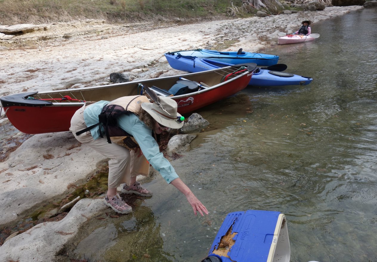
An abandoned ice chest and Reiko both display good form at the final drop at ledge rapids.


Susan using the Force.


Did I say this was a paddling trip?


Miguel returned for more.


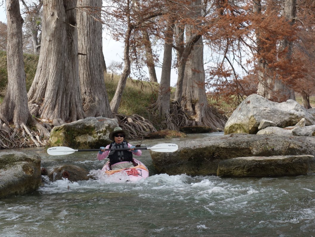
Susan makes a clean run through the rocky narrows.


The river widened and became even shallower as we paddled the two-mile loop between Seidensticker Crossing and the take-out at James Kiehl River Bend Park.


A short distance up the hill from the road crossing next to the park is an old cemetery.  A sign notes that three Civil War veterans are buried there.  I'll let you guess for which side they fought.  It is safe to say that they were not among the thirty-four conscientious objectors to the Confederate draft who were killed (some executed after being taken prisoner) at the 1862 Nueces massacre, and who are now honored by the Treue der Union Monument erected in 1866 in Comfort.


A Hill Country take on the Christmas tree.  Perhaps it sprouts these decorations only once every hundred years.


Robert, Susan, Rick, Joline, and I enjoyed a "snack" at the Waring General Store.  It is across the street from the Waring Country Store, and there apparently is a feud brewing between the two.  We have patronized both places and haven't taken sides.

Note:  For all 39 photos from this outing, click here and then click on "Slideshow."
 

Thursday, December 6, 2012

Three-4-Thursday


Stairway to Heaven


At about 3.3 miles into our San Juan River trip, we spotted our first of several toehold routes.  The footholds, sometimes locally called "Moki Steps," were carved into the sandstone by the Anasazi and provided precipitous routes up steep cliff faces.


These ancient Indian footholds are now quite worn, and visitors should not attempt to climb them.  We certainly didn't.
  
Note:  With apologies to Led Zeppelin
  

Wednesday, December 5, 2012

Wednesday Wildlife


A raven (Corvus corax) boldly searches for treasure next to our kitchen area at Ledge Camp, located at Mile 19.4 next to Ledge Rapid and the site of our third night on the San Juan River.  We asked him to locate the camp table sacrificed to the rapids earlier in the day by Mike, but quoth the raven "Nevermore."  As we learned many days later at Government Rapid, this mischievous bird spoke untruthfully. 
  

Tuesday, December 4, 2012

Two-4-Tuesday


San Juan River


Mike views part of the Butler Wash Petroglyph Panel, also known as the Big Kachina Panel, located just downstream of Butler Wash.  The life-sized figures are believed to be about 2,000 years old, dating back to the Basketmaker period.

Saturday, December 1, 2012

Saturday Paddlers - San Antonio River - Saspamco Paddling Trail


The Saturday Paddlers returned to the Saspamco Paddling Trail to see what improvements may have been completed since our initial visit in April.  The trail and that first trip are described in this post.


Rather than paddle the entire 12.1-mile trail, this time we put in at the river access site on CR 125, which is about the midpoint of this stretch of the San Antonio River.  We discovered that the access road to the ramp was still under construction, but were able to get our boats down to the metal stairs leading to the river.  The photo above was taken from the bridge just downstream from the ramp.


Next to the bridge is another tourist attraction of which we were not previously aware.  The Riverside Ranch is a "lifestyle friendly" clothing-optional RV/mobile home park and campground.  Maybe next time a "paddling trip" will take on a whole new meaning!


 Sandra and Joline can't agree on which direction is downstream.


Jon, Amy, Kathy, and Sandra enjoyed the leisurely paddle.


 A very large tree didn't quite block our path.


We stopped for a snack on one of the few rocky banks.  Amy, Mike, Kenny, Joline, Jon, Sandra, and Kathy found comfortable seating.


Our river trip ended at the Helton Nature Center on Hwy. 775.  We then drove a few miles to the Maverick Grill, located on U.S. Hwy. 181, for an early dinner.  No one complained about the fried fish, steaks, enchiladas, salad, and chocolate milk shake, and I imagine that we will be back.

Note:  To see all nine photos from this outing, click here and then click on "Slideshow."